
(Maps by Sasha Trubetskoy)
How Sasha Trubetskoy tried to break the internet with maps.
On his website, Sasha Trubetskoy, Class of 2019 (statistics), describes himself as an “internet-famous cartographer.” In his spare time he makes maps and posts them on Reddit. Some end up being seen by millions of people.
Interview has been adapted and edited.
I’ve always been super into atlases, maps, things like that. Other kids would read Harry Potter; I would read the atlas.
In high school I’d go on Wikipedia, which has plenty of lists. I would digest those lists and put them on a map—countries by gross domestic product, something like that.
When I was a high school junior in January 2014, we had a snow day. In Northern Virginia it takes about three inches of snow. Miami, they get a dusting and they close school. What about the rest of the country? There was no data, so I posted a survey on Reddit. Maybe a couple hundred people filled it out. I plotted those points on a map and eyeballed it, super unscientifically. Since Reddit was how I got my survey information, I was like, thanks, here’s what the map looks like.
Then I went to sleep. I wake up, and my best friend is like, dude. He sends me a link to Atlantic.com. I’m thinking, Oh great, this is going to be some political article. I click on it—wow. The whole thing is dedicated to my little map.
I got an email at one point that was super scary and official sounding, asking for publication rights. I realized this was a book publisher. They paid me $300, which was mind-blowing, and put it in a book called America’s Best Infographics 2015.

My next big map was the one on the United States GDP. I was wondering, how can I split it into two halves that would be the most disproportionate looking, the most shocking? This was before Trump—it was 2014. People online made a lot of comments about the urban-rural divide.
I’m not trying to be political with my maps at all. I think they can be interpreted in a lot of different ways, which I think has helped my appeal. Everyone takes away their own message. For a lot of people, it’s a political message.
I post on a subreddit called Map Porn, the premier place for interesting maps on Reddit. If you post at around 8 or 9 a.m. Eastern time, that hits a critical amount of people who are not just awake but at work. They are not fully working yet, they’re browsing the internet.
I learned from Reddit that if a Canadian sees something that mentions Canada, they will upvote out of solidarity. You can game that. So I made a map of every Canadian province, if every Canadian province proposal had succeeded. Not many people know Jamaica was going to be part of Canada. That map got me on Huffington Post Canada.
I was like, Canada worked, let’s try Australia. Same idea, every Australian state proposal. That worked too.
A very popular recurring theme in viral maps is a fictional subway network of some sort. I can see why people like that. It’s cute, it’s bright colors, everything’s nice and organized, it’s fun to look at.
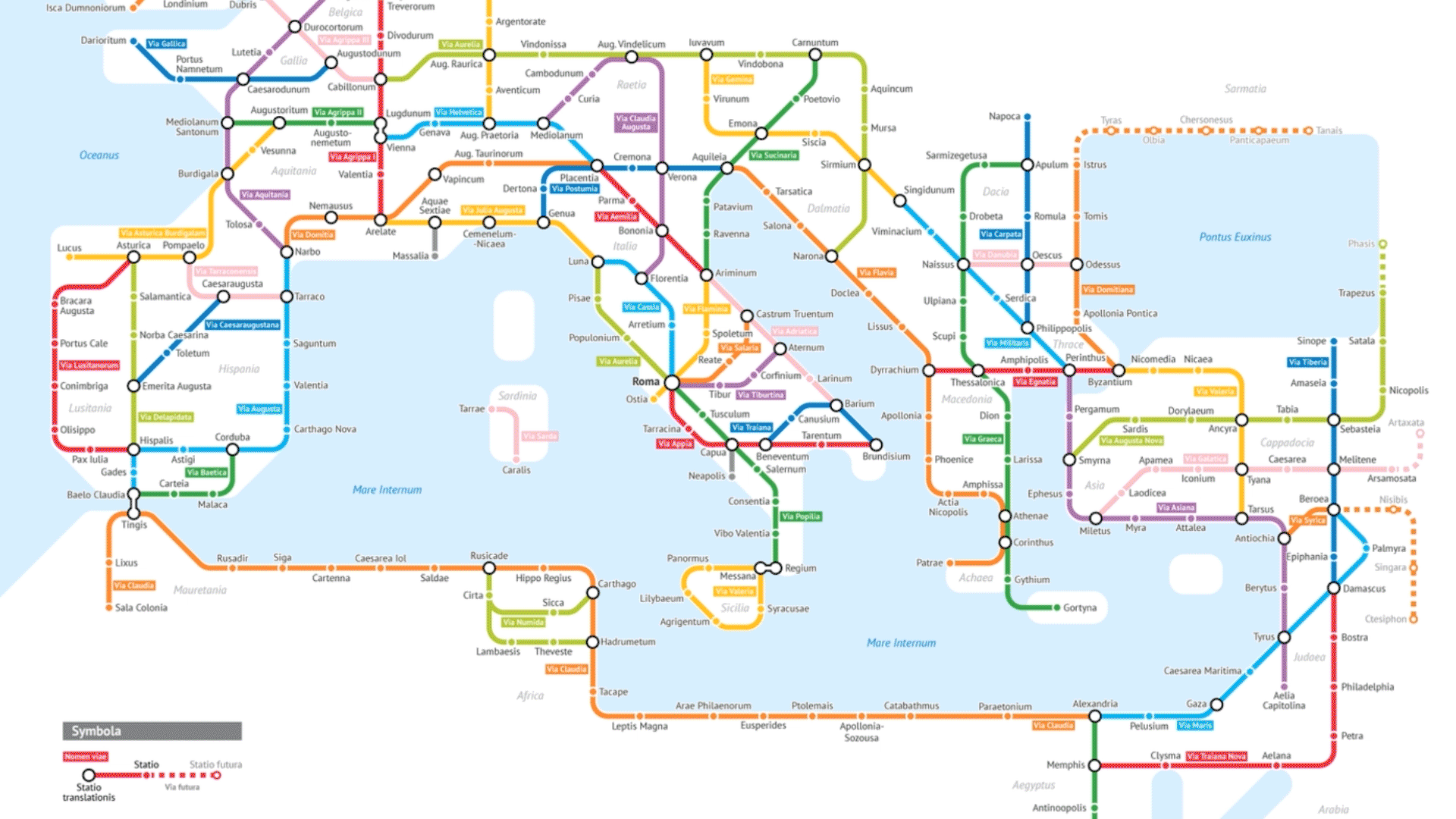
Somehow I stumbled upon the idea of representing the ancient Roman road network. I tried to make it look like a modern publication that the actual Roman Empire would have, like little leaflets at the train station. The map is in Latin. I don’t know Latin, but I have a knack for picking up little bits and pieces, maybe born out of necessity from my childhood. My parents come from Moscow, and at home we only spoke Russian. My grandma speaks French.
Latin has six cases, Russian has six cases, and they’re essentially the same. I had an intuition, like, how would I say this in Russian? Then replace the words with Latin. It turns out that’s a fantastic way of doing it.
The first people who came to me were a Spanish newspaper. The Roman legacy is huge in Spain. Then some Italian writers, British, recently some Japanese website. Mental Floss, Citylab, the Atlantic, Design Boom.
I put up a link for people to download it and print it into a poster. I think around 800 or so people did. The Paypal link said $9 by default. It came to around seven, eight thousand dollars. It’s been mind-blowing. And a lot of people sent more than $9. One guy from Germany sent 50 euros.
A handful of people tried to trick me. You can change the currency on Paypal, so they would send me like, nine yen. The best was nine Philippine pesos, which literally didn’t register as a single cent. So I had to decline that payment.